
The Power and Challenge of Digital Elevation Models
Using AI & Machine Learning to Overcome Shortfalls in DEM Availability
Introduction
In a world increasingly driven by geospatial data, Digital Elevation Models (DEMs) have become a cornerstone in understanding and managing our physical environment. From urban planning to climate modeling, DEMs serve as the 3D blueprint of Earth’s surface, revealing the contours, slopes, and elevations that shape how we live, build, and respond to natural forces.
But while their value is immense, regularly updated DEM imagery remains surprisingly hard to come by. Why? Let's explore both the importance of DEMs and the complex challenges of keeping them current.
What are DEMs & Why Do They Matter?
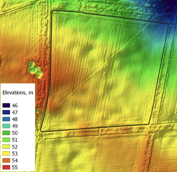
Fig. 1 - An example image highlighting the change in elevation over a site visually © Deep Planet 2025
A Digital Elevation Model is essentially a 3D grid of elevation data. Each cell in the grid represents the height of the Earth’s surface at a specific location. When layered with other geographic data, DEMs help reveal how terrain influences natural processes, infrastructure, and human activity.
At Deep Planet, we regularly use DEM imagery in our own analysis for customers, providing important insights that may be useful when modelling crop physiology in different regions. Beyond agriculture, there are a large number of applications of up to date DEM imagery.
Here’s how DEMs are used across different sectors:
Disaster Management: Predicting flood zones, landslide risk, and post-disaster damage assessment.
Urban Planning & Infrastructure: Designing road networks, drainage systems, and building foundations based on terrain suitability.
Agriculture & Forestry: Managing water flow for irrigation, evaluating soil erosion, and planning crop patterns on slopes.
Environmental Science: Modeling watersheds, tracking glacier movement, or mapping sea-level rise impacts.
Telecommunications & Defense: Planning line-of-sight for signal towers or assessing visibility for surveillance and military operations.
Their utility is virtually endless. Accurate, high-resolution elevation data can transform the way we manage land, respond to disasters, and even design smart cities.
So Why Aren’t DEMs Updated More Often?
Despite their significance, regularly updated DEMs are rare—especially outside major urban areas or research zones. Here’s why:
1. High Cost of Data Collection
Generating a DEM isn’t as simple as taking a photo. It requires specialized methods such as LiDAR (laser scanning), photogrammetry (from aerial imagery), or radar satellites. These techniques involve aircraft or satellites, expert teams, and powerful processing tools—all of which carry a hefty price tag.
2. Slow-Changing Terrain
In most places, terrain doesn’t change rapidly unless affected by events like earthquakes, landslides, or large-scale construction. As a result, frequent updates are often deemed unnecessary from a cost-benefit standpoint.
3. Data Processing and Storage Demands
High-resolution elevation data generates enormous datasets. Updating a DEM means reprocessing and revalidating all that data—a computationally intensive and time-consuming effort, especially at national or global scales.
4. Limited Resources and Funding
Most DEMs are produced or commissioned by government agencies or research institutions. With limited budgets, these organizations must prioritize where and when to update. Remote or low-population areas often fall to the bottom of the list.
5. Environmental and Technical Barriers
Some areas—like dense forests or perpetually cloudy regions—pose serious challenges for accurate data capture. Satellite-based methods might be blocked, while aerial surveys may be too risky or restricted.
Deep Planet and DEMs
The reality is that access to recent DEM imagery is still limited—and often reserved for places where it's most urgently needed or economically justified. Despite the hurdles, the future is promising. Advances in automated data processing, and cloud computing are making it more feasible to update DEMs more frequently and affordably. Satellite missions like NASA's ICESat-2 and the TanDEM-X project are providing more regular elevation updates at increasingly finer resolutions.
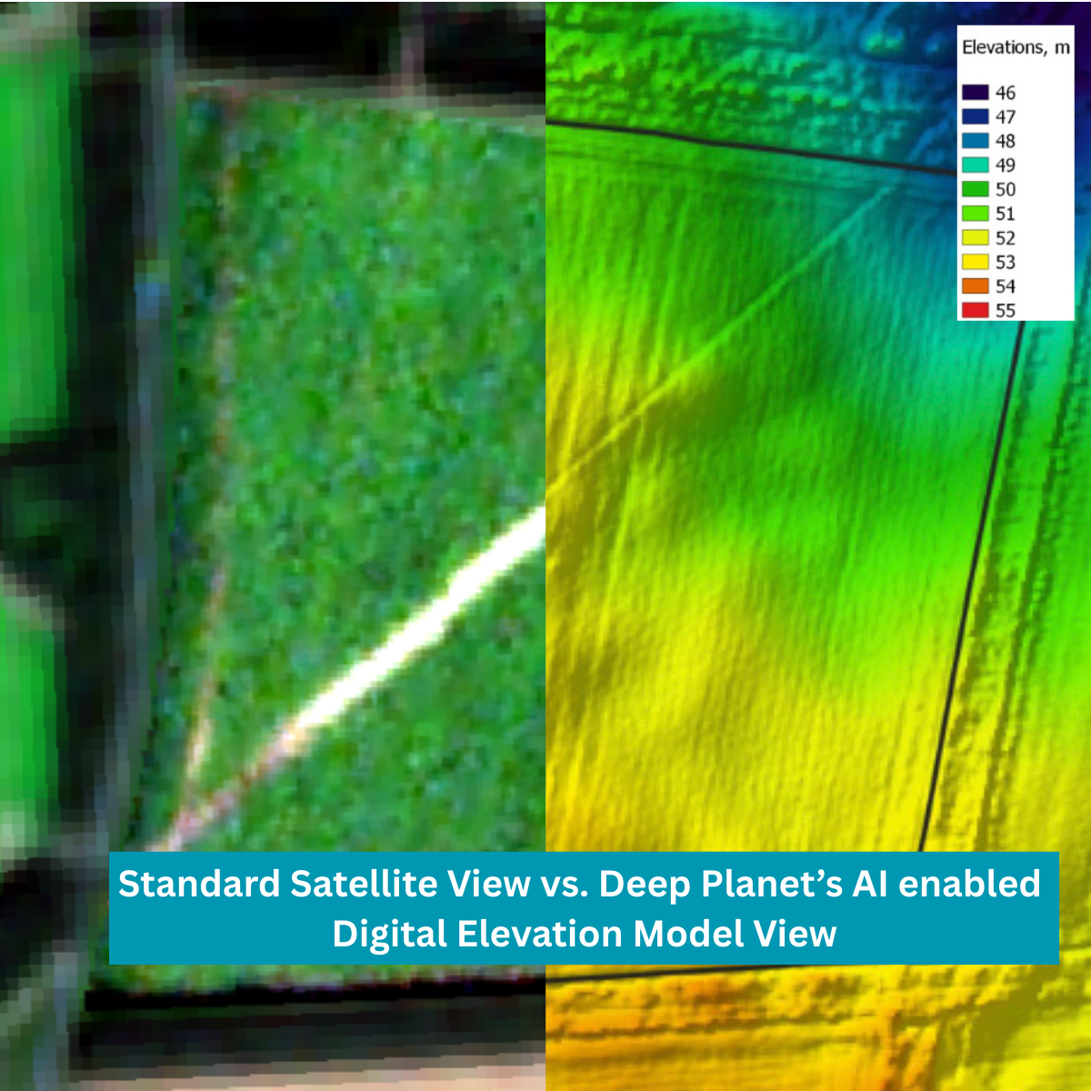
Deep Planet provides elevation monitoring services outside of timelines afforded by publicly available DEM imagery. Using high resolution optical imagery, to produce a temporal assessment of the change in land cover types in the area of interest, we assess the developments that have occurred over time.
Using this time series analysis of land cover change, it is possible to produce calibrated baseline DEM maps for the region of interest. By incorporating pre-existing DEM imagery with up to date Planet satellite images we produce an accurate, high resolution representation of elevation in the region for key dates, helping our customers
Deep Planet uses these baseline DEM maps, in conjunction with high resolution imagery captured across the project window, to produce a time-series of bespoke DEM maps across a project lifecycle. Alongside the individual DEM maps at each time point, we then illustrate the relative change in elevation over time. Our clients use DEM’s for
Water Management and Irrigation: Inefficient irrigation, poor drainage, and water runoff are major issues for farmers, leading to crop loss and environmental damage. By accurately mapping the elevation, slopes, and flow paths of a field, Deep Planet’s DEMs allow optimal irrigation and run off planning.
Soil Health and Degradation: Soil erosion, often caused by water runoff on slopes, leads to the loss of fertile topsoil and a decrease in long-term farm productivity. DEMs are a key input for Deep Planet's AI models that monitor soil health, guiding targeted soil sampling plans.
Strategic Crop Planning and Management: A farm is not a uniform block of land. Variations in elevation can affect everything from sun exposure to microclimates, which impacts crop growth and yield. Deep Planet's platform uses DEMs to define management zones, inform crop selection and optimise harvest logistics.
Asset Due Diligence for Investors: Investors and governments need to quickly and accurately assess the health and risk profile of a land asset. Deep Planet’s DEMs provide a crucial layer of data for due diligence, helping evaluate land quality and assess climate risk.
Conclusion
Digital Elevation Models are fundamental to understanding and managing the Earth's surface. They shape how we predict floods, plan cities, and respond to environmental change. Yet, despite their value, up-to-date DEMs remain hard to access due to the complex and expensive process of generating and maintaining them.
Deep Planet is working towards a future where dynamic, real-time terrain models become more accessible—not just for governments and scientists, but for anyone working to understand and shape the world around them.
Unlock the Future of Elevation Modelling with AI-Driven Insights!
Discover how Deep Planet is transforming regional data collection with cutting-edge satellite imagery and machine learning.
Find out how real time elevation modelling can help your business today.